
|
|
|
|
|
Useful Links |
||
TAF Weather Forecast /
Decoded TAF for KCOU, 50 nm northeast of 24MO.
|
||
|
|
|
For information please contact:
To accommodate non-member transient pilots wishing to land and use the airport a single time, please refer to the following link:
Mistwood Airport Transient Pilot Policy and Release Form
| FAA Identifier: | 24MO |
| Lat/Long: | 38-07-57.7200N / 092-49-49.6600W 38-07.962000N / 092-49.827667W 38.1327000 / -92.8304611 (estimated) |
| Elevation: | 875 ft. / 267 m (estimated) |
| Variation: | 04E (1985) |
| From city: | 13 miles NW of CAMDENTON, MO |
| Time zone: | UTC -5 (UTC -6 during Standard Time) |
| Zip code: | 65020 |
| Airport use: | Private use. Permission required prior to landing |
| Activation date: | 01/1978 |
| Control tower: | no |
| ARTCC: | KANSAS CITY CENTER |
| FSS: | COLUMBIA FLIGHT SERVICE STATION |
| Attendance: | UNATNDD |
| Wind indicator: | yes |
| Segmented circle: | no |
| UNICOM: | 122.8 |
| WX AWOS-3 at OZS (12 nm SE): | 120.225 (573-317-0412) |
| WX AWOS-3PT at AIZ (13 nm E): | 135.325 (573-348-0847) |
| VOR radial/distance | VOR name | Freq | Var | |||
|---|---|---|---|---|---|---|
| SHYr297/12.1 | SUNSHINE VOR/DME | 108.40 | 00E |
| NDB name | Hdg/Dist | Freq | Var | ID | |||||
|---|---|---|---|---|---|---|---|---|---|
| SEDALIA | 152/38.0 | 281 | 03E | DMO | -.. -- --- | ||||
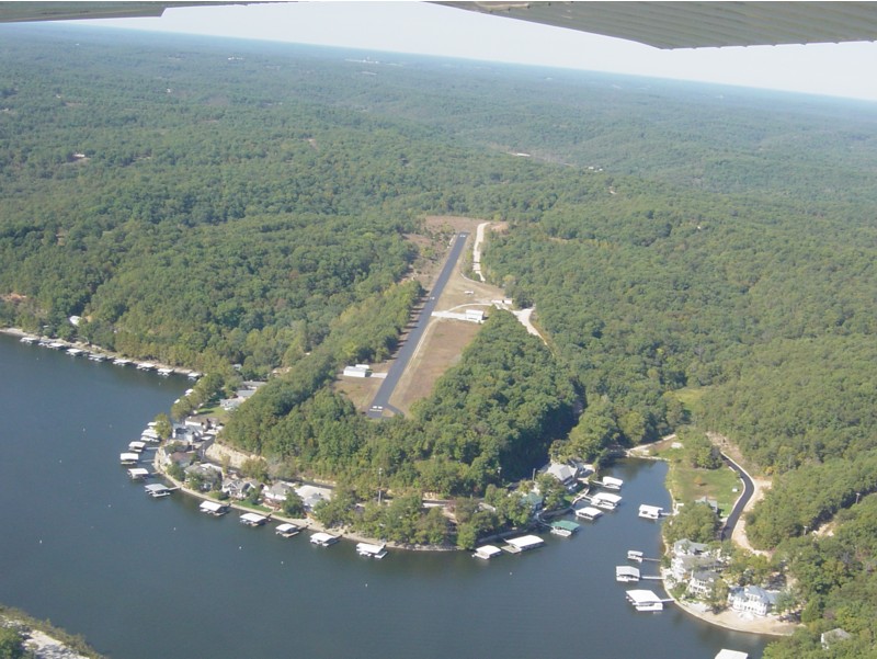
| Dimensions: | 2830 x 36 ft. / 863 x 11 m | ||
| Surface: | asphalt | ||
| RUNWAY 7 | RUNWAY 25 | ||
| Latitude: | 38-07.945800N | 38-07.978200N | |
| Longitude: | 092-50.122200W | 092-49.533250W | |
| Elevation: | 875.0 ft. | 815.0 ft. | |
| Traffic pattern: | left | left | |
| Ownership: | Privately-owned |
| Owner: | MISTPORT, LLC 2404 NORTHLINE INDUSTRIAL DR. ST LOUIS, MO 63043 Phone 314-743-5000 |
| Manager: | DONALD S MC LAUGHLIN 2404 NORTHLINE INDUSTRIAL DR. ST LOUIS, MO 63043 Phone (314) 566-7619 |
|
|
Some nearby airports with instrument procedures:
K15 - Grand Glaize-Osage Beach Airport (7 nm E)